India’s drone industry has entered one of the most exciting phases of its existence. A landmark liberalisation of drone regulations in 2021, followed by the government’s Production Linked Incentive scheme for domestic drone manufacturing and a series of high-profile government deployments, has transformed drones from niche gadgets into serious commercial tools. The drone rental and mapping business sits right at the centre of this transformation — and for entrepreneurs with the right equipment, skills, and certifications, it is proving to be a genuinely profitable and fast-growing venture.
The Market: Policy-Backed and Rapidly Expanding
India’s drone market is projected to reach $1.8 billion by 2030, growing at approximately 18–22% annually. The government’s Drone Shakti initiative and the sweeping liberalisation under the Drone Rules 2021 have dramatically reduced entry barriers, simplified licensing, and opened new sectors for commercial drone operations.
Agriculture alone covers 140 million hectares increasingly requiring precision monitoring. Roads, railways, power lines, and pipelines need regular aerial inspection. Real estate developers, mining companies, and urban planners are active buyers. Wedding photography provides steady entry-level volume while operators build expertise for higher-value industrial work.
Services You Can Offer
Aerial Mapping and Surveying — Generating high-resolution orthomosaic maps, 3D terrain models, and contour maps for infrastructure, agriculture, mining, and real estate. Highest value service category.
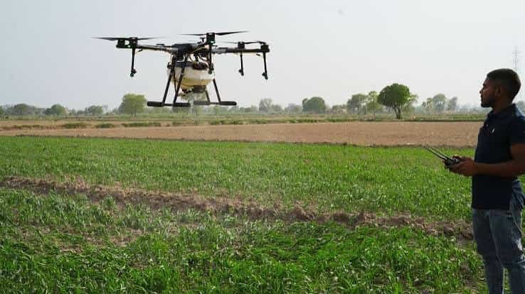
Agricultural Drone Services — Crop health monitoring using multispectral imaging, soil analysis mapping, and precision agriculture support. Strong government backing through schemes promoting drone use in farming.
Infrastructure Inspection — Aerial inspection of power lines, bridges, pipelines, wind turbines, and construction sites. Reduces human risk and dramatically cuts inspection time and cost.
Wedding and Event Photography — High demand, lower margins per project, but consistent volume. Good entry point for building flight hours and client relationships.
Investment Required
Drones are the primary capital investment, and quality matters enormously for professional mapping work.
A basic entry setup with a consumer-grade drone suitable for photography and basic aerial work costs ₹3–8 lakh including the drone, spare batteries, controller, and basic mapping software subscriptions.
A professional mapping operation with a survey-grade drone like the DJI Phantom 4 RTK or equivalent, processing software like Pix4D or DroneDeploy, and ground control point equipment requires ₹15–35 lakh.
Beyond equipment, certification costs under DGCA (Directorate General of Civil Aviation) rules, remote pilot licensing, and drone registration are essential and relatively modest at ₹20,000–50,000.
Revenue and Profit Potential
Pricing in drone services varies significantly by application. Agricultural mapping surveys charge ₹800–2,000 per acre. Infrastructure inspection projects are priced at ₹30,000–1.5 lakh per day depending on complexity. Orthomosaic mapping for real estate or construction sites runs ₹15,000–60,000 per project. Wedding and event shoots charge ₹10,000–40,000 per event.
A solo operator or small two-person team maintaining a full project schedule can generate monthly revenues of ₹1.5–5 lakh. A professional outfit with 3–4 drones, dedicated pilots, and GIS processing capabilities serving institutional and government clients can generate ₹8–20 lakh monthly with net margins of 35–50% — driven by low recurring costs once equipment is purchased.
What Drives Profitability
Certifications and Compliance: Operators with full DGCA compliance — registered drones, licensed pilots, proper insurance — access government and institutional contracts that pay significantly more than private work. Certification is not just legal necessity; it is a business advantage.
Software Expertise: Processing aerial data into maps, 3D models, and reports using Pix4D or ArcGIS is what clients pay premium prices for. This technical depth separates serious operators from hobbyists.
Challenges to Navigate
Regulatory Complexity: Despite liberalisation, drone operations still require navigating no-fly zones, airspace permissions, and evolving DGCA guidelines. Operators who stay current with regulatory changes maintain their operational freedom; those who don’t face grounding.
Equipment Risk: Crashes, component failure, and rapid technological obsolescence require ongoing investment and solid insurance.
Skilled Pilot Shortage: Finding DGCA-licensed pilots is increasingly competitive. Building a reliable certified team is a genuine challenge as the business scales.
The Verdict: Technical, Profitable, and Future-Ready
The drone rental and mapping business in India is one of the most forward-looking business opportunities available today. It combines cutting-edge technology, strong government support, diverse revenue streams, and genuinely high margins into a single enterprise. Operators who invest in the right equipment, earn the right certifications, and develop deep mapping expertise will find themselves in high demand for years to come.
Frequently Asked Questions (FAQs)
Q1. How much does it cost to start a drone rental and mapping business in India?
A basic photography and rental setup requires ₹3–8 lakh. A professional survey-grade mapping operation needs ₹15–35 lakh. Full commercial operations with multiple specialised drones can require ₹40–80 lakh. DGCA certification and registration adds ₹20,000–50,000.
Q2. What certifications are required?
DGCA drone registration, a Remote Pilot Certificate for each operator, and compliance with Drone Rules 2021. Airspace permissions are needed for controlled zones. Commercial insurance is strongly recommended and often mandatory for institutional contracts.
Q3. How much can a drone mapping business earn monthly?
A solo or two-person operation earns ₹1.5–5 lakh monthly. A professional multi-drone outfit serving institutional clients generates ₹8–20 lakh monthly with net margins of 35–50%. Government survey contracts significantly boost revenue stability and volume.
Q4. Which sector pays the most?
Infrastructure inspection and government surveys pay the highest rates. Mining, power line surveys, and large-scale agricultural mapping are the most lucrative. Wedding photography generates volume but at lower margins.
Q5. Is this business viable outside of metro cities?
Absolutely. Agricultural mapping, rural property surveys under SVAMITVA, infrastructure projects, and mining operations are concentrated in non-metro and rural India. Cities like Bhubaneswar, Raipur, Ranchi, and Nagpur are surrounded by agricultural land, infrastructure projects, and mining activity — making them strong bases for drone service businesses.
Q6. What is the biggest risk?
Equipment damage and regulatory non-compliance. Comprehensive insurance, strict pre-flight checklists, and staying current with DGCA rules are essential. Operators who skip these face consequences that wipe out months of profit.
The sky is no longer the limit — for drone operators in India, it is just the beginning.